 IMAS Metadata Catalogue
Great Barrier Reef
Type of resources
Topics
Keywords
Contact for the resource
Provided by
Years
-

Seagrass meadow extent and meadow-scape was mapped using three alternative approaches at Midge Point, a coastal turbid water habitat, in the central section of the Great Barrier Reef, in September/October 2017. Approach 1 included mapping meadow boundaries and meadow-scape during low spring tides on foot using a handheld Garmin GPS. Approach 2 was where the meadows were surveyed at low tide with observations from a helicopter, with observational spot-checks conducted at a number haphazardly scattered points. Approach 3 used PlanetScope Dove imagery captured on 09 October 2017 coinciding as close as possible to the field-surveys, with 3.7 m x 3.7 m pixels (nadir viewing) acquired from the PlanetScope archive. This record describes meadow extent data collected using Approach 3 (PlanetScope imagery). View the original metadata record at https://doi.org/10.1594/PANGAEA.946606 for the full data collection.
-

Seagrass meadow extent and meadow-scape was mapped using two alternative approaches at Green Island, a reef clear water habitat, in the Cairns section of the Great Barrier Reef, in November 2020. Approach 1 included mapping seagrass meadow-scape using imagery captured during low spring tides with a DJI Mavic 2 Pro UAV at an altitude of 100 m, with a resolution of 2.45cm/pixel. Approach 2 used PlanetScope Dove imagery captured on 05 November 2020 coinciding as close as possible to the field-surveys from 25 to 27 November 2020, with 3.7 m x 3.7 m pixels (nadir viewing) acquired from the PlanetScope archive. This record describes meadow extent data collected using Approach 2 (PlanetScope imagery). View the original metadata record at https://doi.pangaea.de/10.1594/PANGAEA.946605 for the full data collection.
-

The study involved the collection of field data and acquisitioning of satellite imagery to create a map that presents a benthic inventory of reefal habitat areas within Moreton Bay. Mapping was guided by the most recent reef map (Queensland Environmental Protection Agency, 2004), the new field data, local knowledge and/or visual interpretation of high spatial resolution satellite imagery. The inventories for each reefal area were based on georeferenced spot check field data collected by volunteer teams in 2015 and 2016 (n=610). This field data was overlayed on high spatial resolution ZY-3 satellite imagery (5 m x 5 m pixels) captured in June 2014. Polygons were manually digitised around reefal areas by an expert from the Remote Sensing Research Centre using visual interpretation of the texture and colour of the pixels in the satellite imagery, as related to water depth, field data and local field knowledge. Polygons were subsequently assigned one of three categories (Coral on reef matrix, Soft Coral on Sand/Rubble, and, Algae on sand/rubble). The project was a collaborative citizen science project between Reef Check Australia, The University of Queensland Remote Sensing Research Centre and Healthy Waterways to collect benthic inventories for eight key subtropical reefal areas in Central Moreton Bay - Mud, Saint Helena, Green, King, Macleay, Goat, and Peel Islands, and, Myora Reef.
-

Seagrass meadow extent and meadow-scape was mapped using four alternative approaches at Yule Point, a coastal clear water habitat, in the Cairns section of the Great Barrier Reef, between October 2017 and July 2020. Approach 1 included mapping meadow boundaries and meadow-scape during low spring tides on foot using a handheld GPS. Approach 2 was where the meadows were surveyed at low tide with observations from a helicopter, with observational spot-checks conducted at a number haphazardly scattered points. Approach 3 used imagery collected during low spring tides with a UAV at an altitude of 30 m with a resolution of 0.2cm/pixel. Approach 4 used PlanetScope Dove imagery captured on 05 September 2017 and 09 August 2019 coinciding as close as possible to the field-surveys in 2017 and 2019, with 3.7 m x 3.7 m pixels (nadir viewing) acquired from the PlanetScope archive. This record describes meadow extent data collected using Approach 4 (PlanetScope imagery). View the original metadata record at https://doi.pangaea.de/10.1594/PANGAEA.946604 for the full data collection.
-
The distribution of seagrass and associated benthic communities was mapped between the 29 July and 29 August 1997 on the reef and lagoon at Low Isles, Great Barrier Reef. For this survey, a total of 349 benthic survey points were examined by observers walking or free‐diving at survey points positioned approximately 50 m apart along a series of transects. To assist with mapping meadow boundaries, an additional 177 points were assessed and a 1:12,000 rectified aerial photo was commissioned (26th August 1997). A differential handheld global positioning system (GPS) was used to locate each point assessed. 127.8 ±29.6 hectares of seagrass was mapped.
-
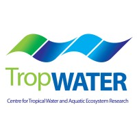
Sediment derived from the decomposition of Halimeda algae is a major contributor to the tropical back-reef carbonate depositions. Halimeda bioherms occur extensively on the northern Great Barrier Reef (GBR), Australia. This dataset represents the most complete, high-resolution spatial mapping of the extent of northern GBR Halimeda bioherms, based on airborne lidar and multibeam echosounder bathymetry data. Three distinct morphological sub-types are described: reticulate, annulate, and undulate. The northern GBR bioherms cover an area of 6095 km2, three times larger than previous estimates.
-

Mangroves are a globally important ecosystem subject to significant anthropogenic and climate impacts. Tidally submerged forests and those that occur in arid and semi-arid regions are particularly susceptible to sea level rise or are growing at the margins of their their ecophysiological limits. The spatial extent of these types of mangroves over broad scales are typically poorly documented as their structural and environmental characteristics make them difficult to detect using remote sensing models. This study utilised the entire Landsat 8 satellite collection between January 2014 and June 2021. A new cloud-based time-series method was used that accounts for tidal variance in detecting mangrove areas that are periodically inundated and have historically been difficult to detect with traditional remote sensing methods. A habitat area model was derived for remote North-western Australia and detected an additional 32% (76,048 hectares) of mangroves that were previously undocumented. The accuracy of the model was assessed within the distinct geomorphic zones of the region through visual validation from high-resolution imagery. See accompanying report for full methodology: Hickey, S.M.; Radford, B. Turning the Tide on Mapping Marginal Mangroves with Multi-Dimensional Space–Time Remote Sensing. Remote Sens. 2022, 14, x. https://doi.org/10.3390/rs14143365
-
Approximately 2,362 ±289 km2 of seagrass meadows were mapped in the waters of Hervey Bay and Great Sandy Strait between 6 and 14 December 1998. This was the first comprehensive survey of the Great Sandy region. The survey involved examination of 1,104 field validation points and identified 174 individual meadows. Seagrass extended from the intertidal and shallow subtidal waters to a depth of 32m. Seven species of seagrass were identified (Cymodocea serrulata, Halodule uninervis, Syringodium isoetifolium, Halophila decipiens, Halophila ovalis, Halophila spinulosa and Zostera muelleri) within 22 seagrass meadow/community types. Mapping survey methodologies followed standardised global seagrass research methods for intertidal, shallow subtidal (2‐10m depth) and deep waters (>10m) using both in situ and remote assessments. View the original metadata record at https://doi.org/10.1594/PANGAEA.876714.